


Tech Feature: The Mavic 3 Multispectral
What makes this DJI drone so special?

Seeing hidden issues in your orchards… requires the right tools!
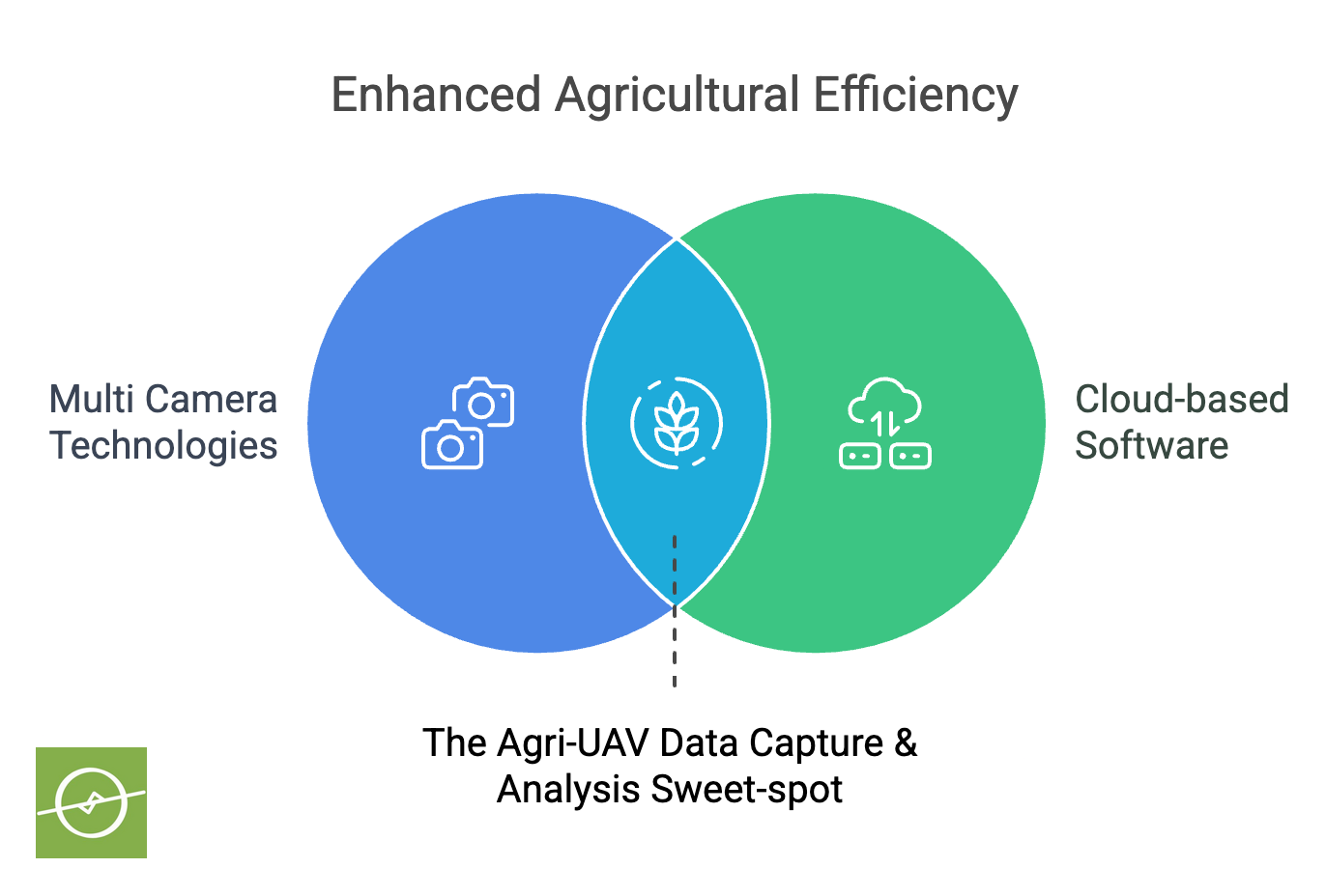
The DJI Mavic 3M Multispectral Edition (also known as the DJI M3M) pairs an RGB camera with a multispectral camera. This combination provides a detailed view of crop health status.
Believe it or not, this powerful data-collection combo has been a tactic employed by companies like Aerobotics for more than a decade.
Why focus on the Mavic M3M specifically?
The barrier to entry for aspiring drone pilots and farmers alike, has traditionally been quite high. The cost of equipment and hardware availability, a major part of the challenge.
The DJI M3M setup is a lot smaller, as well as more affordable to procure and maintain. Keeping this in mind... the high-value data these types of surveys produce has become more accessible than ever before. It’s quite literally a game-changer. A drone-tech adoption accelerator enabling drone service providers, software companies, and the end-users (farmers) alike.
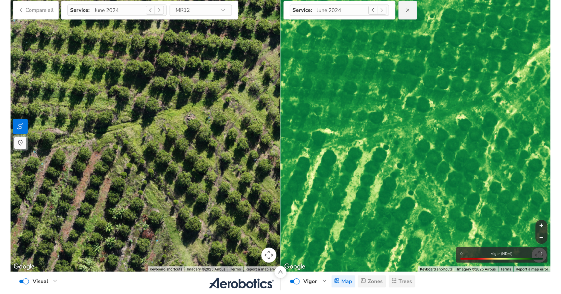
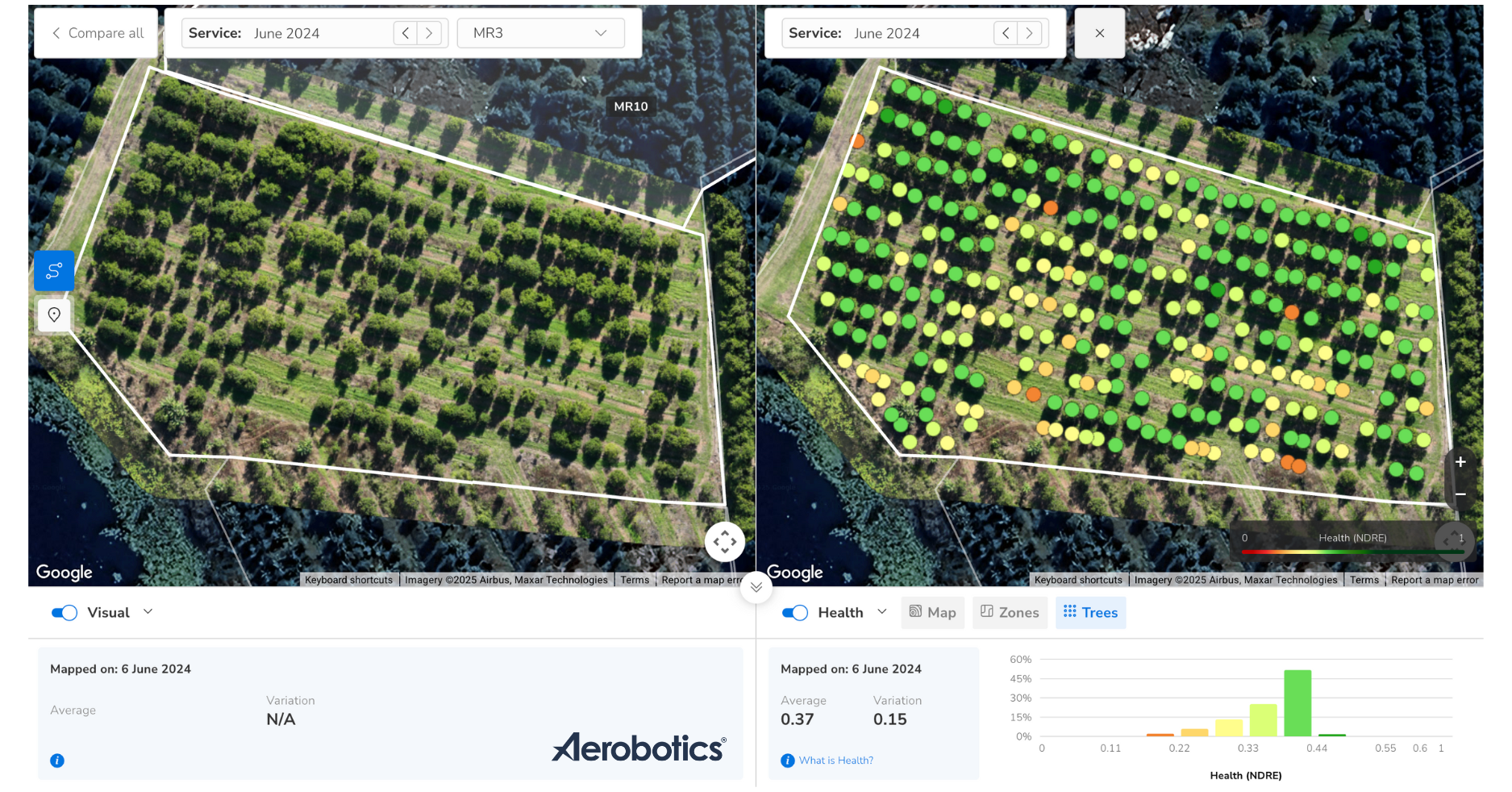
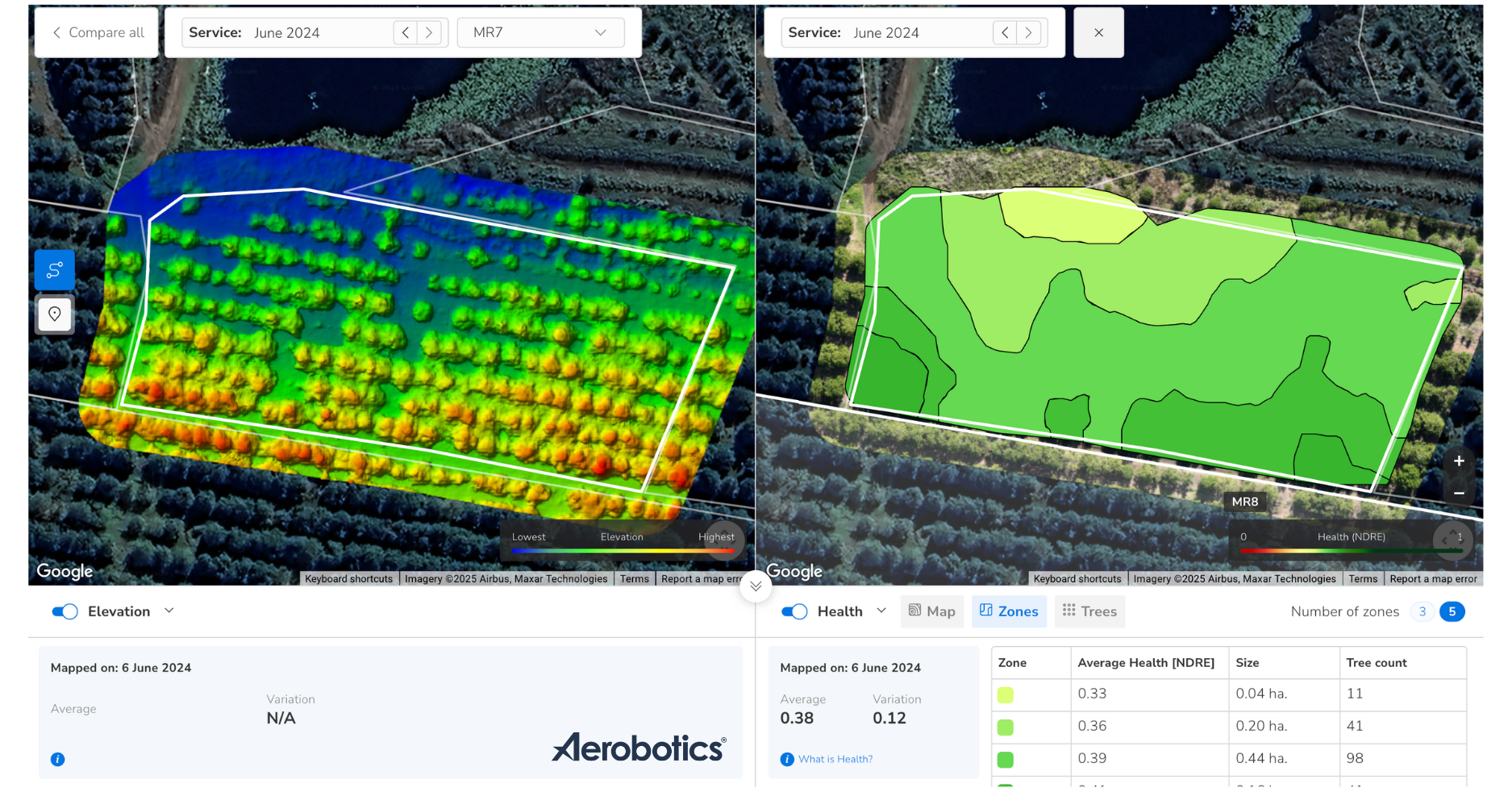
The best part? Multiple drone metric outputs at your disposal with split-screen views. Especially useful when it comes to the analysis of the survey results. Diagnosing of potential issues and anomalies, and setting up next-steps for interventions.
In the case of the Aerobotics platform, the multispectral values can be displayed as either NDVI or NDRE metrics, and in three view options:
Map layers
Zonal views
Per-plant metrics
Multispectral information helps us to spot high stress or low health issues early on. Way earlier than one would do otherwise with the naked eye. The bird's-eye-view gained from a drone overhead makes for high-efficiency top-down screening.
And over and above the split-screen views comparing metrics... one can review survey data; comparing results across drone survey dates as well. Great for tracking changes over time.
Additionally, one can setup tasks for in-field inspections (mobile app integration). Share information via in-platform chats and discussions (creating a diagnostic archive). Export data results for offline scrutiny or sharing online (optional).
“The DJI M3M is transforming the way we conduct agricultural surveys, with advanced technologies and ease-of-use. But most of all, technologies crammed into a tight compact package that can go anywhere with ease. A workhorse piece of kit that comes with a whole new level of convenience.”
And affordability? When compared to larger setups like the DJI Matrice 350 RTK paired with 3rd party payload sensors, the M3M setup comes in at only a fraction of the cost.
With a 20-megapixel RGB camera with a four-thirds CMOS sensor, the image quality is superb for a drone and camera this size, getting the job done. While RTK positioning delivers centimetre-level accuracy, synchronised to the microsecond.
Every camera exposure is precisely recorded, efficiently and quickly. This allows the drone to survey up to 200 hectares in one flight, without ground control points.
It’s not unheard of for an experienced drone pilot flying in favourable weather, being able to survey around 350 hectares in a single outing (with a couple of battery changes of course).
In this way, farmers are able to procure high-quality datasets with ease. High-res visuals and multispectral information as standard. But also canopy sizes, elevation, and tree census statistics too. Info from each drone survey optimises key operations. Activities like spraying, fertilising, irrigation, and VRAs.

Of course, plant growth and sizes of plants vary within a field (ie. orchard variance) making targeted (or variable) fertilisation essential nowadays.
Using advanced AI-backed platforms, farmers can generate vegetation indexes. These highlight differences in crop size, growth, stress, and vigour.
Once again, these vegetation insights form part of the puzzle for creating precise VRA prescription maps. Cutting overall costs and reducing environmental impact, while maximising yield potential.
The M3M absolutely excels in crop scouting. Images are uploaded in real time via a 4G network to the DJI Smart Farm platform. Alternatively, straight to the Aerobotics platform post-survey via WiFi connection for automated processing. Expertly built AI-backed software, with state-of-the-art analysis tools and diagnostic solutions.
These cloud-based platforms enable quick identification of areas under undue stress. Including outliers and anomalies; quantifying the magnitude of the problem o rpattern of concern.
As mentioned, cloud-based sharing makes collaboration seamless. And the platform’s AI tools assist with yield monitoring and strategic planning. Even larger farms can be managed efficiently by a single operator. In turn, high quality data becomes a lever for taking action. An advantage enjoyed by heads of operation, production managers, and agronomists alike.
Beyond standard tree crops, the Mavic 3M is useful for surveying cash crops. maize, wheat, cotton, potatoes, and more. Equipped with DJI O3 transmission, it can cover vast areas, including mountains, forests. But most importantly: orchards and vineyards.
A downward-facing vision sensor helps it maintain altitude over uneven terrain, improving efficiency. Through the Aerobotics platform, it can count trees (and gaps in rows) and display differences in ground-cover.
The M3M can even generate 3D flight routes for other agricultural drones. Making spray application by drone even more precise, and safer than ever.
The Mavic 3M is built to boost efficiency and sustainability in farming. It enhances productivity, while reducing costs. Minimises environmental impact. And makes our modern era of agriculture smarter and more effective.
Hats off to DJI for an amazing piece of kit.
In Summary:
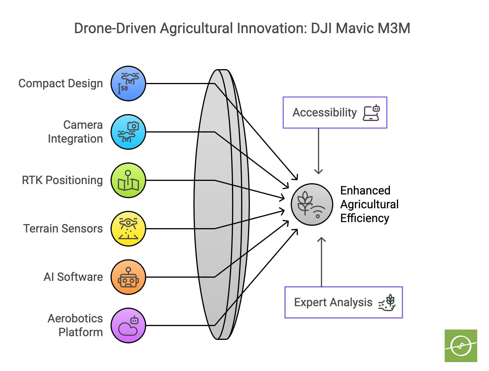
The smaller compact design compared to other multispectral setups makes for unsurpassed utility, convenience, and affordability.
The M3M combines RGB and multispectral cameras for detailed analysis.
RTK positioning ensures high accuracy, allowing efficient surveys without ground control points.
Terrain-following sensors improve efficiency in challenging landscapes.
AI-powered software aids in identifying plant health issues and crop risks quickly.
Integration with DJI Smart Farm enables general mapping, and helps to generate drone spraying programs.
When data is uploaded to the Aerobotics platform this allows for expert analysis, access to first-in-class cloud-based solutions, task setting, collaboration, knowledge archiving, integration with scouting tools like advanced mobile apps, and VRA map generation (to name a few).
» Mapping a Field with a Multispectral Drone | DJI Mavic 3M
» DJI Mavic 3 Enterprise Multispectral Comprehensive Review
» DJI Mini 3 Pro Preflight Checklist: Thing To Do Before You Fly