


Macadamia Yield Forecasting: AI and Remote Sensing Strategies
Guesswork or Precision: which would you choose? Read about how AI, drones and mobile apps are revolutionising macadamia yield forecasting.

In my mind, it's absolutely essential to explore current advancements in crop forecasting. A miscalculation can lead to supply chain disruptions, price fluctuations, and financial losses.
Advancements include crop monitoring, yield prediction, labor management, and technology implementation like solution-stacking. Addressing limiting factors, reducing variance, and optimising production, among others.
When it comes to Macadamia farming, we have only begun to scratch the surface of what is possible. And like the cracking of this noble nut itself, we have our work cut out for us.
It's tougher than it seems.
But it is possible.
Fortunately, technology offers solutions through artificial intelligence (AI) and remote sensing. By leveraging these tools, farmers can improve accuracy, efficiency, and decision-making.


The new kid on the block is the Aerobotics TrueFruit product.
And it's currently taking the fruit world by storm.
The Macadamiasphere?
Not quite yet. But we're getting there.
If you're farming fruit and berries, there’s nothing that comes close to what Aerobotics’ TrueFruit solution provides.
An advanced data-capture app infused with AI, working in tune with the platform backing it. Moreover, accurate size, colour and blemish statistics for each orchard, cultivar, or farming region. And remember, this is done in-the-field. Ahead of sophisticated post-harvest scanning in a pack-house or processing plant!
Now, the TrueFruit solutions do tie into our macadamiasphere in some way, providing value to nut growers. And why it’s so exciting, is in how it links up with the drone data platform.
While focusing on nut-in-husk (NIH) size (as one would do for a crops like citrus or apples) is not yet a core ask from producers, I believe it will be an important data point in years to come as market demand strengthens. And in particular, demand for larger kernels from a consumer base of foodie connoisseurs who know what they want.
The link between nut processors and producers must also be kept front-of-mind. Producers will often be asked for an indication of their nut size expected for the season.
With smart-sampling backed NIH growth curves, and a record of husk thickness per cultivar per farm, per region (well, one can get as specific as you want really) an accurate nut-in-shell (NIS) figure is reached. No more guessing nut size. Moreover, it can even be forecasted after nut-drop! Months ahead of harvest.
How the core Aerobotics drone tech works:
A drone scans an orchard.
The pilot uploads the data to the cloud.
Processing software produces data metrics specific to each tree.
Next, the data outputs at per-tree level are used to generate waypoints in the orchard. The most representative trees to sample.
Read more in PART 2 of my post about nut yield forecasting:
Countering risky guesstimates with AI-backed smart-sampling…

The Challenge of Yield Forecasting
Yield forecasting is currently a complex exercise for many farmers due to:
Lack of structured methodologies
Time and resource constraints
Limited access to technology
Variability in orchard conditions
An incorrect forecast affects multiple stakeholders. This leads to issues like market volatility, storage problems, and reputation damage.
To overcome these hurdles, farmers can use various yield monitoring strategies.
Guesstimates…
A qualitative approach that uses logic and assumptions to estimate yields.While simple, it lacks precision and leads to errors.
Historical Data Analysis…
Examining past yield trends to predict future output.While useful, historical data doesn't account for sudden changes like extreme weather events.
Mechanical/Physical Sampling…
In-field sampling provides real-world data.But accuracy depends on factors like sample timing and orchard variability. Also labour intensive. The forecast is only as accurate as (1) the method employed to do the sampling, and (2) the amount of data gathered. Oftentimes datasets are too small and are not representative.
Remote Sensing…
Using satellite imagery, drones, and in-field telemetry.Capturing large-scale data on vegetation health, canopy sizes, or growth patterns. Sophisticated models produce a generalised view on yield. Some can account for climate related inputs too.
Smart Sampling…
AI-driven sampling that selects representative trees.This reduces human error and improves forecasting accuracy. Strikes a balance between time spent in-field and an appropriate amount of data. Mobile app technologies allow for quicker collection of data with higher accuracies. Quicker turnaround times, and less human error.
The last two methods are arguably the way of the future (for those not utilising these resources already). And the beautiful things about them is that by marrying the two, you get the best of both worlds.
The Power of Remote Sensing
In the context of leaning into my current scope of knowledge, I'm only outlining two remote sensing options right now. Namely Satellite imagery, and Drone based imagery.
I'm aware that in-field telemetry adds a new dimension to tracking real-time crop status. However, it's perhaps a topic for separate post. And deservedly so. Especially where water-use is concerned. Also, when paired with additional telemetry information such as those from soil probes.
Example: Phytech
…"bridging the gap between growers and their plants, delivering real-time insights and actionable recommendations to optimise irrigation, enhance crop health, and simplify farming." to quote them directly.
Satellite-Based Forecasting:
Satellites provide a broad view of orchards, using multispectral and hyperspectral sensors to predict yields. They can deliver block-level forecasts up to two months before harvest. However, limitations include:
High costs and data accessibility barriers (specifically for yield forecasting)
Dependence on weather conditions (cloud-cover)
Low spatial resolution (compared to drone surveying)
Drone-Based Forecasting:
Drones offer high-resolution imagery and advanced analytics. They provide per-tree data, enabling precise anomaly detection and targeted interventions. Unlike satellites, drones allow real-time adaptability and improved orchard management efficiently.
An affordable cost for high-accuracy crop monitoring (drone + mobile app)
Smart Sampling and AI Integration
How does AI enhance yield forecasting?
By leveraging remote-sensing outputs - mostly drone-derived data - and pairing these with an in-field mobile app, and the Aerobotics cloud-based platform (AKA TrueFruit)
This gives us:
AI-generated sample points – Ensuring representative tree selection.
An advanced Mobile app – Streamlining data collection and reducing errors.
AI-powered extrapolations – Using tree census data to refine predictions.
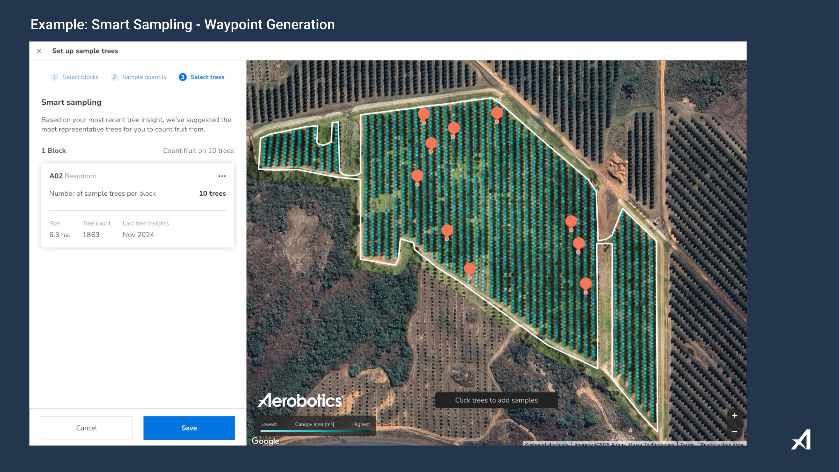
The smart-sampling process includes:
Farm digitisation/s
Drone survey + analysis
AI-based sample point generation
In-field data collection (nut counts, sizing, etc.)
Data reviews and calibration
The data review and calibration step is mostly focused on data collection efficiency. Also, if sample routes are producing the required dataset mass. Other factors like data quality (human error at point of collection) are looked into. And any other challenges that might have come up are addressed.
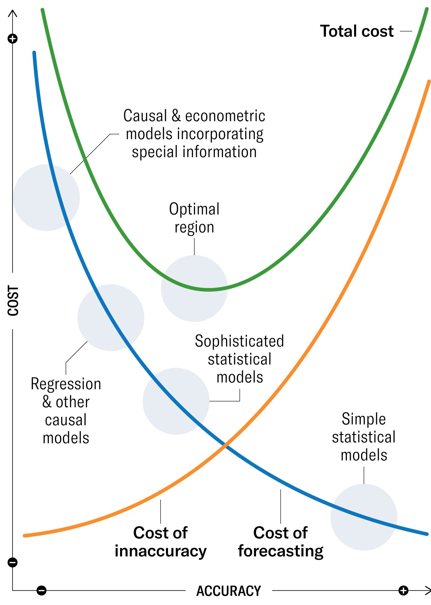
Balancing Cost and Accuracy
Investing in high-tech sampling, means balancing the cost of forecasting with the financial risks associated with inaccuracy.
Leveraging smart-sampling technologies enables improved forecasting accuracy. A reduction in human error. Enhanced operational efficiency. And enables resilient practices, and flexible farm management.
My advice?
Find the balance between the cost of forecasting (the cost of the solution/tools/implementation) ...and the cost of inaccuracy (financial loss, etc).
There’s a graph that comes to mind. And although born in the financial arena, it’s one which still maps and visualises this “sweet spot” nicely:
In closing, remember that yield monitoring does not have to be a guessing game.
With AI-driven forecasting and remote sensing tools, macadamia farmers are making informed decisions. Optimising their resources, reducing the unknown, and securing a competitive edge.
Learn more about drone mapping and metrics:
Find me on social: LinkedIn, Instagram, Twitter (X), YouTube
